by Bianca Rompato, Ilaria Incollu, Tommaso Tognetti
How well do we really know the trees in our cities? And more importantly, are we able to act before a potential risk turns into a real problem? These questions guide the tree census carried out within the TREESURE project.
A tree census is much more than a simple inventory; it is a key knowledge tool that provides a comprehensive overview of the urban tree stock. Collecting structured data on biometric parameters, as well as on tree health, structural condition, and site-specific characteristics, provides a solid basis for subsequent analyses. One of the most important outcomes is tree risk mapping. The data collected in the field can help to identify the most sensitive and critical areas of a city, highlighting where action is needed most. This shifts urban green management from a reactive to a preventive approach: not just responding after an event but planning targeted interventions based on evidence. It is not only about knowing, it is about acting!
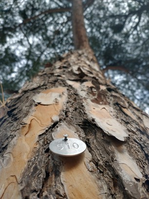
The census activity is part of Work Package 2 (WP2), coordinated by the University of Florence, and follows a shared inventory protocol developed across all project partners. This protocol integrates different layers of analysis, considering not only tree health but also site-specific conditions that may influence the potential risk associated with trees. Each tree has been assigned a unique identification number, ensuring traceability and enabling long-term monitoring. The result is a first, essential snapshot of Cecina’s urban tree stock. More importantly, it provides the basis for the next steps of the project: from detailed risk maps to decision-support tools that can guide timely and targeted interventions. In a context where climate change is increasing the frequency and intensity of extreme events, knowledge becomes a form of preparedness.
In Cecina, this process is already underway, as the city is one of the three pilot cities of the project, together with Soria and Brașov. The census conducted in Cecina recorded approximately 3,344 public trees, representing more than 48 species and distributed across streets, parks, and public spaces.
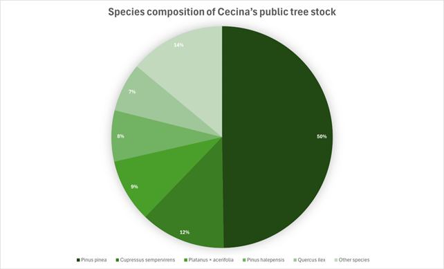
The inventory reveals a relatively rich tree stock, with several species represented across the urban area and a prevalence of taxa commonly found in Mediterranean urban green spaces. In particular, Pinus pinea alone represents almost 50% of the surveyed trees, while the five most common species (Pinus pinea, Cupressus sempervirens, Platanus × acerifolia, Pinus halepensis and Quercus ilex) together account for approximately 86% of the total population.
These results represent an important starting point for the TREESURE project, supporting the development of risk maps, decision-support tools, and more effective urban tree management strategies.